Inland Rail’s NSW/Qld Border to Gowrie section involves delivering approximately 217km of track – 149km of new track and 68km of upgraded track – which runs from 18km southeast of Goondiwindi to Gowrie Junction, northwest of Toowoomba in Queensland.
This section is in the environmental approvals stage. Inland Rail is seeking approval from the Queensland Coordinator-General (Coordinator-General) for the NSW/Qld Border to Gowrie revised draft Environmental Impact Statement (EIS) and its revised reference design, which was on public consultation in mid-2025.
We are currently investigating the feasibility of design refinements to the revised reference design at several locations along the NSW/Qld Border to Gowrie section including at Yelarbon, Pampas, Brookstead, Pittsworth and key road-rail interfaces.
These investigations are possible due to updates to our design standards since the revised reference design was finalised for assessment in 2023. The investigations also provide an opportunity for Inland Rail to further improve the design in response to community feedback.
The potential design refinements aim to reduce the amount of land required for the project, improve safety at road-rail interfaces and minimise impacts to the community, including noise, vibration, earthworks, truck movements and visual amenity.
What happens next?
We’ll report back to the community on the feasibility of potential design refinements once design investigations are complete.
The NSW/Qld Border Gowrie revised draft EIS will be assessed by the Queensland and Australian Governments.
Construction of the NSW/Qld Border to Gowrie project is subject to the Queensland Government granting necessary approvals and future decisions by the Australian Government.
Read more about environmental impact assessments for coordinated projects at www.coordinatorgeneral.qld.gov.au.
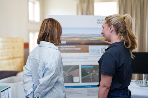
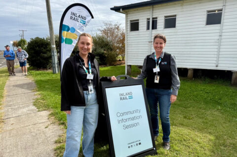
Talk to the team
We’ll be out and about in the community over the coming months. Come to an event and meet with our team to discuss updates to our design standards, the design investigations and the environmental approvals process underway with the Coordinator-General; or any project matters of interest to you.
If you have any questions about the Inland Rail project, you can also contact our Queensland team by phone or email.
The design refinements presented below are indicative only and are shared at this preliminary stage of the refinement investigations to inform the community of the opportunities potentially available to refine the revised reference design.
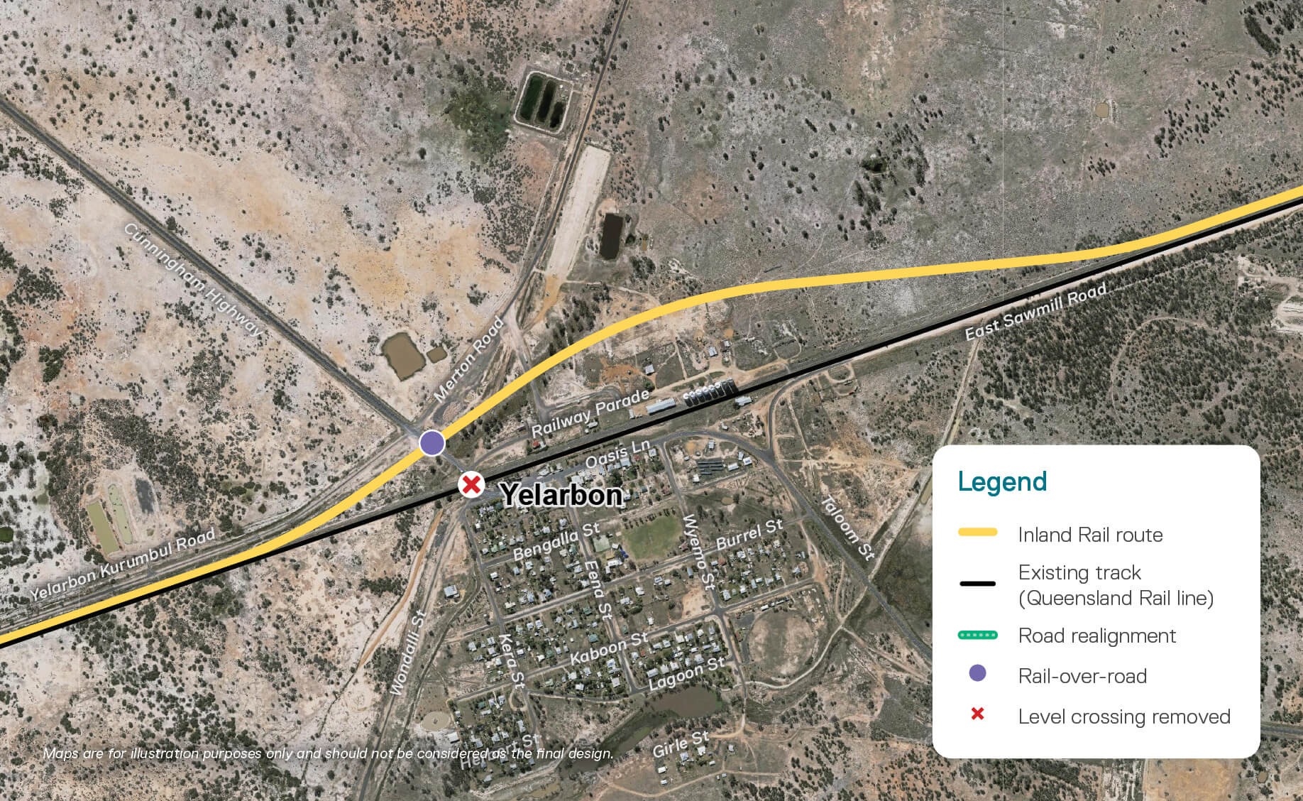
Yelarbon
Inland Rail is investigating a design refinement to bypass the Yelarbon township which will offer significant safety improvements and reduced noise and visual impacts.
Current design: Revised reference design
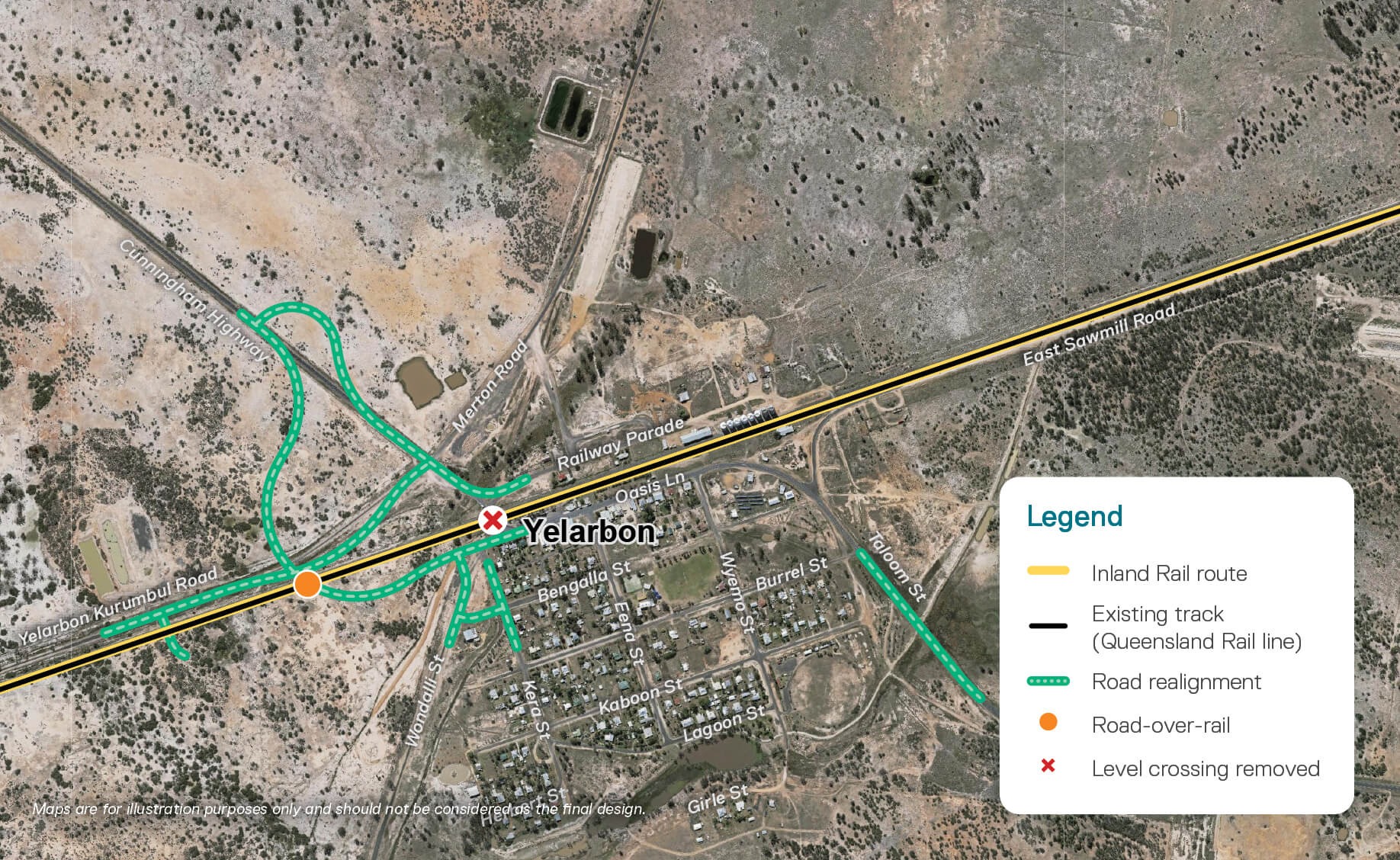
Click on image to view in more detail (in a new tab). Maps are for illustration purposes only and should not be considered the final design.
Design refinements being investigated
Click on image to view in more detail (in a new tab). Maps are for illustration purposes only and should not be considered the final design.
Design refinement investigations:
- proposed alignment to be located approximately 100–200m north of the existing track
- new rail-over-road bridge will replace and remove the current Cunningham Highway level crossing
- noise walls will be installed at track level to reduce rail noise impacts on nearby residents.
Key benefits:
- reduces township impacts away from homes and community facilities
- preserves visual amenity to silo artwork
- removes complex Cunningham Highway road design with a rail-over-road bridge
- improves road safety and enhances traffic flow
- minimal road disruption with local access maintained and no major realignments
- improves cross-town pedestrian connectivity
- avoids impacting existing stock route and maintains connectivity underneath the rail bridge.
For more information, download the Yelarbon fact sheet [PDF, 2 MB].
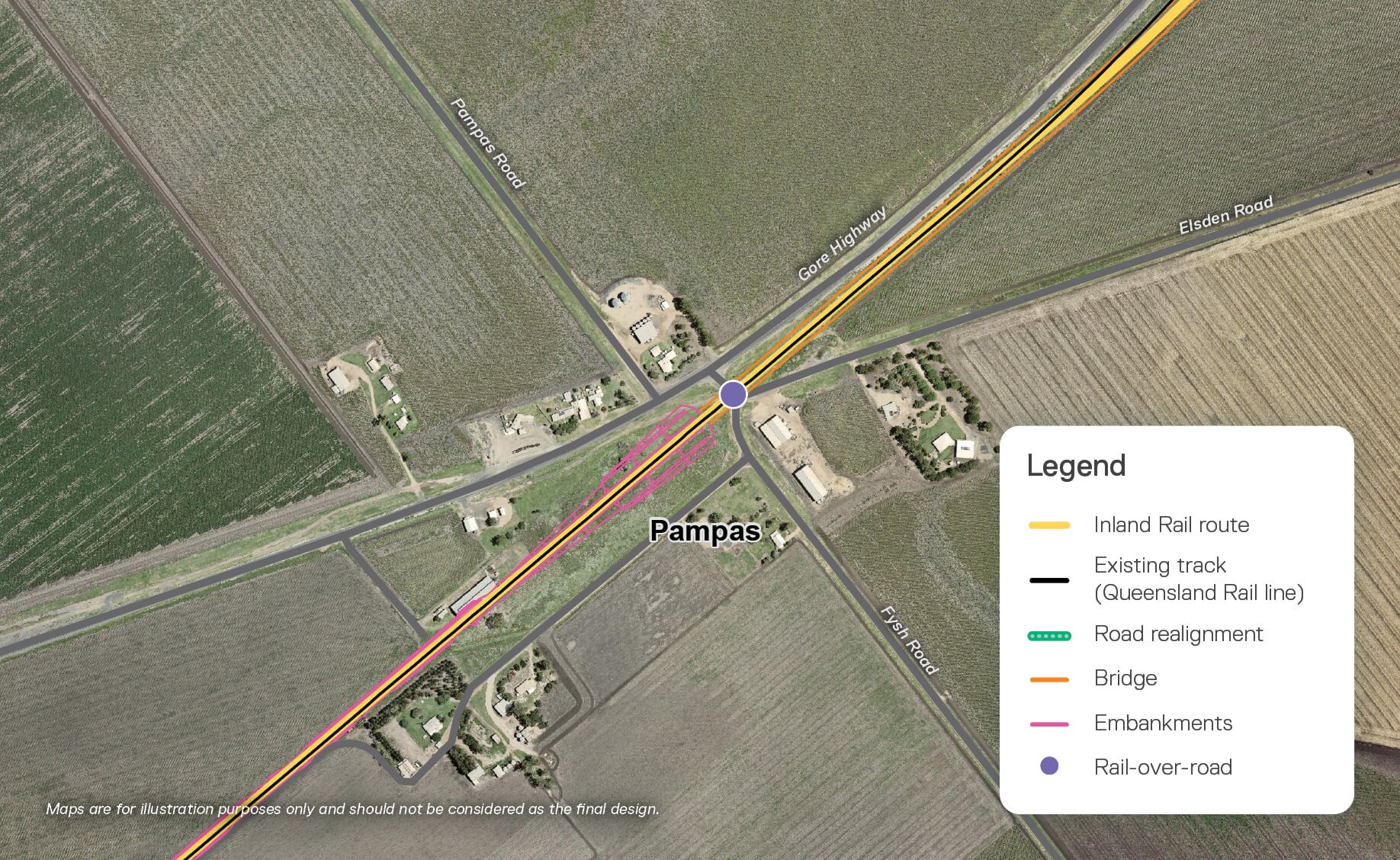
Pampas
Key design refinement investigations at Pampas include introducing a rail-over-road bridge at Fysh Road and extending the bridge to connect with the Condamine River North Branch rail bridge.
Current design: Revised reference design

Click on image to view in more detail (in a new tab). Maps are for illustration purposes only and should not be considered the final design.
Design refinements being investigated
Click on image to view in more detail (in a new tab). Maps are for illustration purposes only and should not be considered the final design.
Design refinement investigations:
- rail-over-road bridge at Fysh Road
- rail-over-road bridge extended to connect with Condamine River North Branch rail bridge (~500m addition)
- removes the need for Harris Road level crossing and Gore Highway upgrade works.
Key benefits:
- retains existing Fysh Road intersection without change to road layouts and property access
- improves safety by removing level crossings and reduces level crossing noise (i.e. boom gate bells and train horn)
- additional bridge structure expected to improve flood mitigation and management.
For more information, download the Pampas fact sheet [PDF, 3 MB].
Pittsworth
Key design refinement investigations at Pittsworth include lowering the rail height near the township, which would improve visual amenity and reduce noise and vibration impacts to nearby residents. This option offers significant improvements for the local community.
Current design: Revised reference design
Click on image to view in more detail (in a new tab). Maps are for illustration purposes only and should not be considered the final design.
Design refinements being investigated
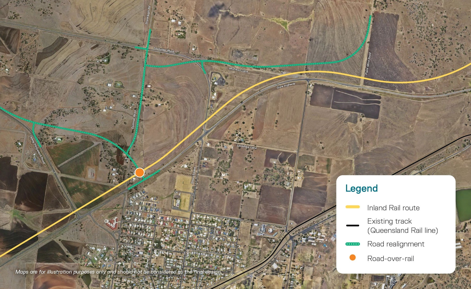
Click on image to view in more detail (in a new tab). Maps are for illustration purposes only and should not be considered the final design.
Design refinement investigations:
- Oakey-Pittsworth Road to be realigned with a proposed road-over-rail bridge connection with the Gore Highway
- closure of existing Oakey-Pittsworth Road intersection
- Dallman Road upgrade with a new intersection to tie into the proposed Oakey-Pittsworth Road realignment.
Key benefits:
- improves visual amenity with the significant lowering of the rail height outside Pittsworth
- approximately a 10m reduction in embankment height at the existing Oakey-Pittsworth Rd interface
- consolidation of five existing intersections into one to improve vehicle safety turning onto and off the Gore Highway
- reduces noise and vibration impacts for nearby residents.
For more information, download the Pittsworth fact sheet [PDF, 2 MB].
Brookstead
Key design refinement investigations at Brookstead include a new rail-over-road bridge at the Gore Highway. This option removes the need for significant road realignment works, optimises connectivity for local roads and improves road safety.
Current design: Revised reference design
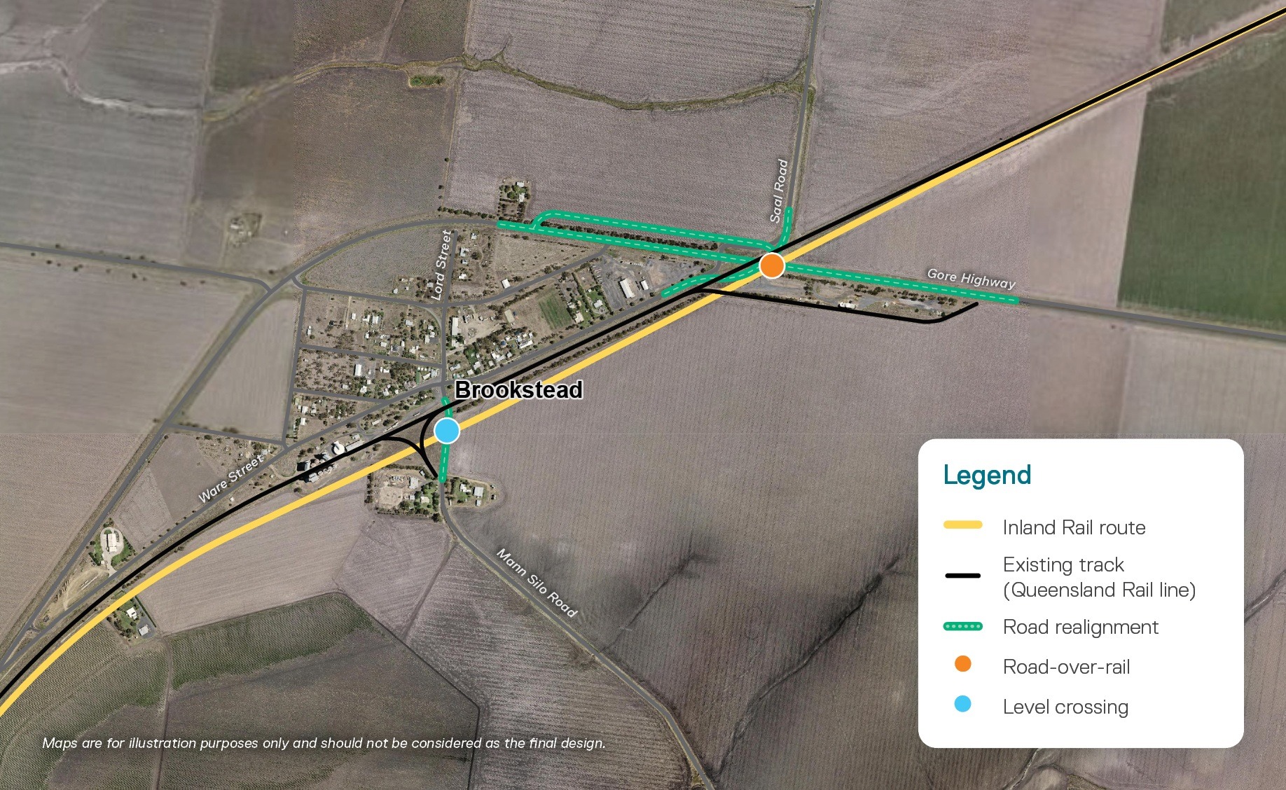
Click on image to view in more detail (in a new tab). Maps are for illustration purposes only and should not be considered the final design.
Design refinements being investigated
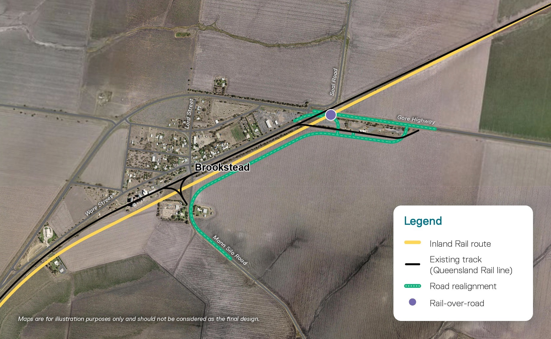
Click on image to view in more detail (in a new tab). Maps are for illustration purposes only and should not be considered the final design.
Locations:
Gore Highway and Mann Silo Road
Design refinement investigations:
- new rail-over-road bridge at the Gore Highway
- realignment of Mann Silo Road for connectivity to Gore Highway and Ware Street
- removal of the active double level crossing on Mann Silo Road
- widening of the Gore Highway to accommodate turning lanes
- realignment of Ware Street to connect to Mann Silo Road for access to Gore Highway.
Key benefits:
- maintains an eastern connection into Brookstead via Mann Silo Road and a new Ware Street connection
- significantly reduces Gore Highway road construction complexity and operational impacts with traffic control
- improves road safety and reduces level crossing noise (i.e. boom gate bells and train horn).
For more information, download the Brookstead fact sheet [PDF, 2 MB].
Road-rail interface design investigations
We are investigating options to refine seven road-rail interfaces across the NSW/Qld Border to Gowrie section. The proposed refinement means there will be no remaining level crossings on State Controlled Roads, improving safety and traffic flows.
| Location | Council area | Existing treatment | Proposed update | |
|---|---|---|---|---|
| Kildonan Road | Goondiwindi | Goondiwindi Regional Council | Active level crossing | Rail-over-road |
| Millmerran-Inglewood Road | Inglewood | Goondiwindi Regional Council | Active level crossing | Rail-over-road |
| Thornton Road | Inglewood | Goondiwindi Regional Council | Active level crossing | Rail-over-road |
| Millmerran-Leyburn Road | Yandilla | Toowoomba Regional Council | Active level crossing | Rail-over-road |
| Linthorpe Road | Linthorpe | Toowoomba Regional Council | Road-over-rail | Rail-over-road |
| Biddeston Southbrook Road | Between Southbrook and Athol | Toowoomba Regional Council | Rail-over-road | Road-over-rail |
| Owens Scrub Road | Millmerran | Toowoomba Regional Council | Road-over-rail | Rail-over-road |
For more information, download the Road-rail interface fact sheet [PDF, 2 MB].
Along the Inland Rail route, there are many points where the rail line crosses a public road. This is called a road-rail interface.
Engineers assess the area to work out which design solution to use at each interface. Options might include installing a level crossing or using a grade separation.
A grade separation is where the road and the railway line cross each other at different heights at the intersection, usually via the use of an overpass or underpass, a bridge or a tunnel. This means that cars do not have to stop to make way for trains.
- Road-over-rail grade separation: This is where the road is runs above the rail line, usually via an overpass or road bridge, so that trains can pass underneath it.
- Rail-over-road grade separation: This is where the road travels underneath the rail line, usually via an underpass or a rail bridge, so that trains can pass safely above it.
A level crossing is where the rail line and the road cross each other at the same level. Cars and other vehicles are required to stop when a train approaches the crossing. There are two main types of level crossings:
- Active level crossings feature flashing lights with or without boom barriers for motorists and automated gates for pedestrians. These devices are activated before and during a train passing through a level crossing.
- Passive level crossings feature static warning signs that are visible on approach. For example, stop and give way signs. This signage is unchanging with no mechanical aspects or light devices. Motorists and pedestrians need to check for trains before crossing the rail line.
Talk to the Inland Rail team
If you would like to contact Inland Rail’s NSW/Qld Border to Gowrie team, you can either call, send an email or visit one of our offices. We also hold regular events across the region, and you’re welcome to subscribe to our enewsletter.
| Phone | 1800 732 761 during business hours or leave a message and we'll get back to you. |
| inlandrailqld@inlandrail.com.au | |
| Inland Rail Pty Ltd, PO Box 3093, Toowoomba, QLD 4350 | |
| Visit us at these locations: | |
| Toowoomba | 143-145 Margaret Street, Monday to Friday, 8.30am-4.30pm |
| Goondiwindi | 28 Marshall Street, Monday, Wednesday, Friday, 10am-2pm |
Alternatively, you can fill out the below form, and request a team member to contact you:
"*" indicates required fields