Ground investigations and aerial survey work – Albury 10 October to 20 December 2024
We will undertake ground investigation and aerial survey work at various locations within the rail corridor and adjacent road surfaces from 10 October to 20 December 2024. The survey data will be captured using LiDAR technology. LiDAR surveys use aerial laser measurements to create a ground surface model to assist planners and designers as they move to detailed design. The investigations will also involve boreholes and other groundworks, which may sometimes be noisy.

Work being done
- Surveying at multiple locations within and adjacent the rail corridor. Surveys may also be required at a small number of locations outside the rail corridor to complete the ground investigation and validation checks
- Utilities investigations involving potholing and use of a vacuum truck
- Locating and mapping underground services using non-destructive digging (NDD)
- Geotechnical investigations using a small drill rig or a small excavator.
What can I expect?
- Survey work will be carried out by one drone pilot with an assistant using a light vehicle within and outside the rail corridor during the hours noted
- Traffic management will be in place to facilitate vehicle and pedestrian movement. To ensure the safety of drivers and workers, please observe all traffic management instructions and signage
- Reduced speed limits of 40km/h near works
- Nearby residents may hear some noise during this time and can expect some additional construction workers and vehicles in the area.
Vehicle movements
During the works, vehicle movements will be limited to moving equipment on and off the sites. The impact to local traffic will be low.
Potential temporary traffic changes
Residents are expected to experience low traffic impacts at the following locations while the project team carry out ground investigations and validation checks under traffic control:
- Albury Station – Atkins Street, Kenilworth Street, Young Street, Wilson Street and Railway Place
- Table Top – Hume Highway and Perryman Lane
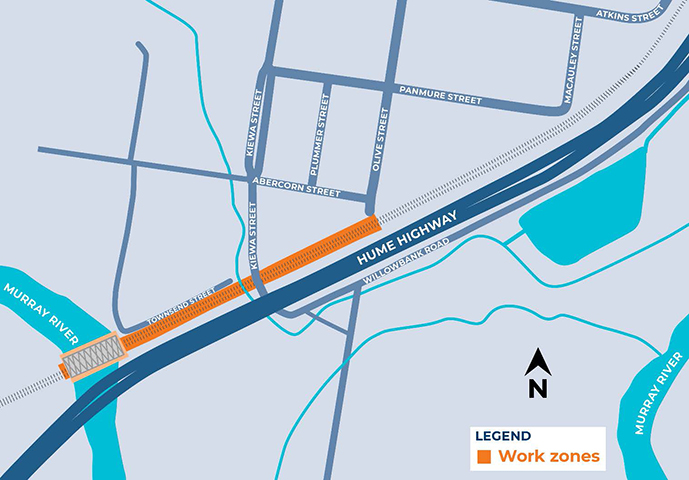
- Murray River Bridge – Wodonga Road, Hume Highway, Townsend Street, Kiewa Street, Lincon Causeway, Harris Road, Willowbank Road, Abercorn Street
Traffic controllers will be available to direct traffic where needed. Please follow all directions of the traffic controller and keep to speed limits.
Machinery used
Equipment used for work includes but is not limited to hand tools, survey equipment, drone, excavators, water carts, vacuum trucks, elevated work platform, track machines, mounted drill rig, heavy and light vehicles.
How we're managing impacts
- Traffic controls will be in place, where required
- Works programmed to best minimise noise impacts
- Use of non-tonal reversing alarms on all equipment and turning off equipment when not in use
- Instructing workers to keep noise to a minimum and being respectful of our neighbours
- Works will be monitored to ensure compliance with Project Approval Conditions.
Contact
Phone: 1800 732 761
Email: inlandrailnsw@artc.com.au
Post: GPO Box 14, Sydney NSW 2001
Thank you for your patience and cooperation while we carry out these works.
Locations of works